- Görsel Tanıma ile Evin Değerini Tahmin Etmek Mümkün mü?
- Yapay Zeka ile Görsel Analiz Nasıl Yapılır?
- Yapay Zeka ile Kentsel Dönüşüm Planlaması
- LeadOcean ile Entegrasyon Fırsatları
- Zorluklar ve Gelecek Perspektifi
- Sonuç: Algılayan Şehir, Değerleyen Teknoloji
Gayrimenkul sektöründe dijitalleşme, sadece fiyat analizleriyle sınırlı kalmıyor. Yapay zeka, artık görsellerden anlam çıkararak evin değerini tahmin edebiliyor ve kentsel dönüşüm gibi karmaşık planlama süreçlerinde karar destek sistemleri olarak kullanılabiliyor. Peki bu teknolojiler nasıl çalışıyor? Gerçekten güvenilir mi? Kentsel dönüşüm örneklerine entegre edilebilir mi?
Görsel Tanıma ile Evin Değerini Tahmin Etmek Mümkün mü?
Görsel tanıma (image recognition), yapay zeka sistemlerinin fotoğraf ve videolardaki nesneleri, desenleri ve yapısal öğeleri algılayabilmesini sağlayan bir teknolojidir. Bu sistem, özellikle emlak sektörü gibi görsel kalite ve çevresel faktörlerin değeri etkilediği alanlarda çok önemlidir.
Yapay Zeka ile Görsel Analiz Nasıl Yapılır?
Evlerin iç ve dış mekân fotoğrafları, CNN (Convolutional Neural Network) gibi derin öğrenme modellerine girdi olarak verilir. Bu sistem, görüntüdeki objeleri (mutfak dolabı, kombi, manzara vb.) tanır ve bunları kalite sınıflarına göre etiketler.
Kullanılan Uygulamalar ve Araçlar:
Google Cloud Vision API / AWS Rekognition: Görseldeki nesneleri tanıyıp etiketlemek için yaygın kullanılan API’ler.
OpenCV: Görüntü işleme ve kenar belirleme gibi düşük seviye analizlerde kullanılır.
YOLO (You Only Look Once): Gerçek zamanlı obje tespitiyle ev içi elemanların sınıflandırılmasında kullanılır.
TensorFlow/Keras: CNN modelleri eğitmek için kullanılan Python tabanlı popüler kütüphaneler.
LabelImg, Roboflow: Eğitim seti hazırlamada manuel etiketleme için kullanılır.
Derin Öğrenme ile Tahmin Süreci:
Ev fotoğrafları yüklenir.
Sistem görüntüdeki kaliteyi etkileyen faktörleri sınıflandırır (örneğin "lüks mutfak" ya da "eski fayans").
Bu görsel veriler, mahalleye özgü fiyatlarla çapraz analiz edilir.
Tahmini piyasa değeri sunulur.
Örnek: İstanbul Beşiktaş'ta Bir Daire
Model, salon fotoğrafında şömine, lake parke ve doğal ışık tespiti yapar. Mutfakta ise üst segment beyaz eşyalar ve ada tipi tezgâh algılar. Tüm bu bileşenler, daha önce fiyatı bilinen 10.000+ daireden öğrenilen bilgilerle kıyaslanarak yaklaşık 13 milyon TL değer tahmini sunar.
Yapay Zeka ile Kentsel Dönüşüm Planlaması
Kentsel dönüşüm planlamasında, yalnızca yapısal risk değil; sosyal, ekonomik ve altyapısal dinamikler de değerlendirilmelidir. Yapay zeka, bu çok boyutlu karar verme sürecini destekleyen güçlü bir araç haline gelmiştir.
Kullanılan Veriler:
Tapu ve Kadastro verileri (bina yaşı, metrekare vb.)
Zemin etüt raporları ve AFAD verileri (deprem riski)
İBB ve diğer yerel yönetimlerin imar planları
Trafik yoğunluğu, yeşil alan oranı gibi çevresel veriler
TÜİK ve e-devlet entegrasyonlu sosyoekonomik istatistikler
Kullanılan Modeller ve Araçlar:
Scikit-learn & XGBoost: Sosyo-ekonomik verilerle mahalle bazlı risk puanı tahmini.
QGIS + Python: Coğrafi veri analizleri ve riskli bölgelerin haritalanması.
LSTM (Long Short-Term Memory): Zaman serisi analizleriyle kira-getiri oranı tahmini.
Google Earth Engine: Uydu verisiyle yapı yoğunluğu ve yeşil alan tespiti.
Gerçek Hayattan Simülasyon: "AI-Kentsel"
Hayali bir yapay zeka platformu olan "AI-Kentsel", İstanbul’daki dönüşüm ihtiyacı olan 10 mahalleyi analiz ediyor. Şu özelliklere göre skorlar üretir:
Bina 1980 öncesi yapılmış: +2
Zemin sıvılaşmaya eğilimli: +2
En az 1 hastane ve 1 okul yoksa: +1
Kira oranları son 5 yılda %30 azalmış: +1
Nüfus > 20.000 kişi/km²: +1.5
Model, bu kriterlere göre Gaziosmanpaşa, Zeytinburnu ve Kadıköy'de bazı alt mahallelerde dönüşüm önceliği olduğunu tespit ediyor.
Entegrasyon: Görsel Tanıma + Kentsel Planlama
Bu iki sistemi entegre etmek, belediyeler için çok değerli olabilir. Örneğin:
Görsel tanıma ile yapı kalitesi analiz edilir.
Kentsel model ile bölgesel öncelik belirlenir.
Sonuçlar, yapay zeka destekli platformda birleştirilir ve mülk sahibine bilgi verilir.
Özellikle İstanbul gibi deprem kuşağında yer alan şehirlerde, bu tür sistemler sadece değerleme değil; hayat kurtarıcı strateji üretimi anlamına da gelir.
Etik ve Sosyolojik Etkiler: LeadOcean ile Entegrasyon Fırsatları
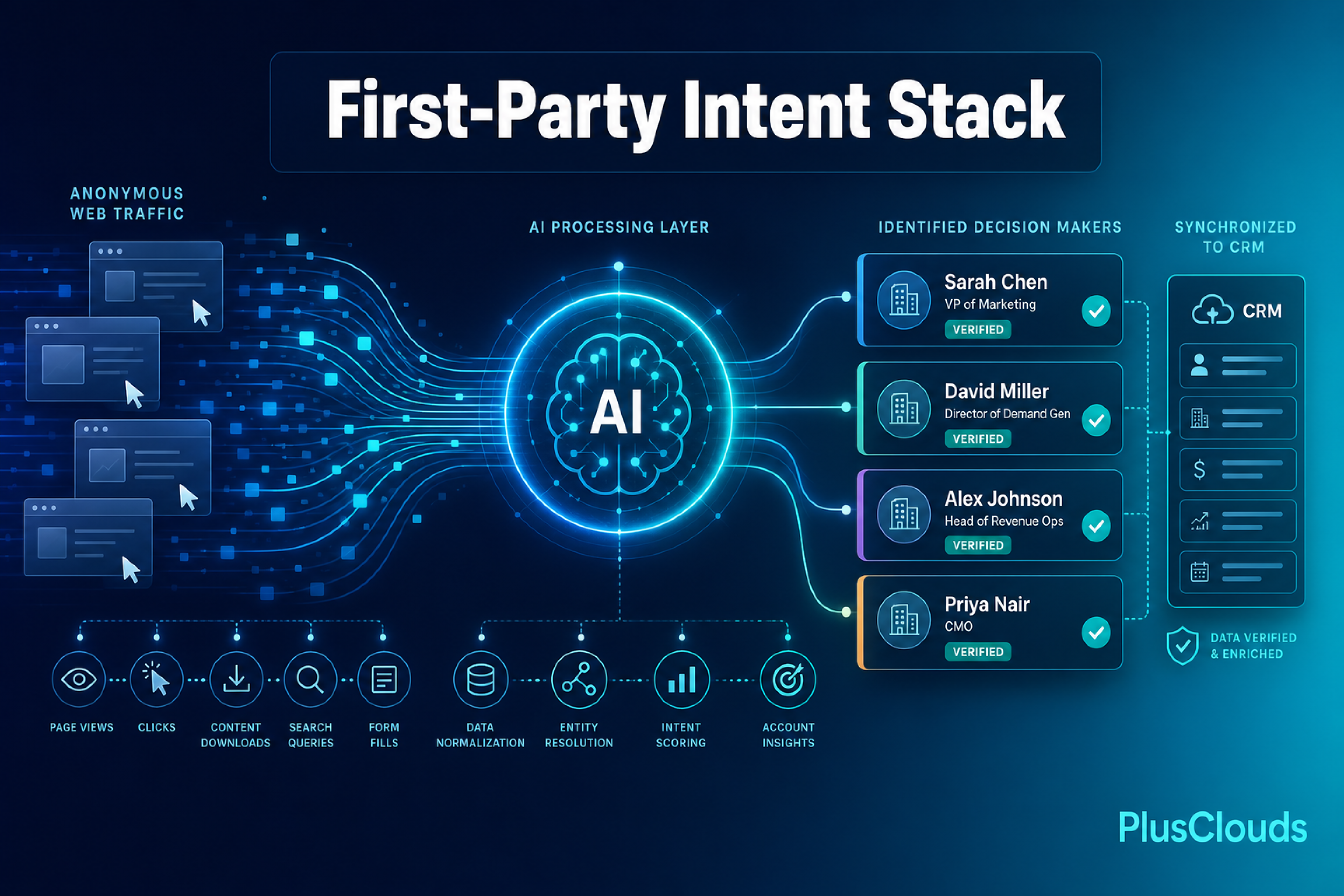
LeadOcean, PlusClouds tarafından geliştirilen, müşteri edinme süreçlerini yöneten veri merkezli, yapay zeka tabanlı bir dijital pazarlama platformudur. Web sitelerinden, dijital kampanyalardan ve CRM sistemlerinden gelen verileri entegre ederek, potansiyel müşterileri bulmanızı sağlar.
Gayrimenkul Sektöründe LeadOcean’ın Potansiyeli:
Gayrimenkul Sektörüne Bir Bakış: Gayrimenkul sektöründe faaliyet gösteren firmaları ve kuruluşları tek tıkla bulmanızı sağlar ve sizin için onlarla iletişime geçer. LeadOcean, işinizi, ideal müşterilerinizi ve potansiyel müşteri özelliklerinizi anlamak için web sitenizi ziyaret eder. Saniyeler içinde, ayrıntılı bir şirket profili oluşturur ve potansiyel müşteri havuzunuzu tam ihtiyaçlarınıza göre düzenler.
Kentsel Dönüşümde Etkileşim: LeadOcean, dönüşüm kapsamındaki mülk sahiplerini, yatırımcıları ve danışmanları ortak bir dijital platformda bir araya getirerek bilgi akışını kolaylaştırabilir.
Hassasiyet için AI Destekli Potansiyel Müşteri Eşleştirme: LeadOcean'un AI'sı, iş profilinizi analiz eder ve kriterlerinize mükemmel şekilde uyan şirketleri bulur. Manuel araştırmaya elveda, yüksek kaliteli potansiyel müşterilere merhaba deyin.
Gayrimenkulde dijital dönüşüm sürecinde, LeadOcean yapay zeka destekli altyapısıyla projelerin sadece planlama değil, pazarlama ve katılım süreçlerinde de akıllı hâle gelmesini sağlayabilir.
Zorluklar ve Gelecek Perspektifi
Zorluklar:
Kaliteli ve güncel veriye erişim (özellikle görsel veri)
Görsel tanımada kültürel farklılıkların etkisi (örneğin yerel mimari özelliklerin sınıflandırılması)
Yasal ve etik çerçeve eksiklikleri
Gelecek:
Türkiye’de belediyelere entegre akıllı dönüşüm platformları
Bankalar için "görsel değerleme raporu" otomasyonu
Tüm şehirlerin dijital ikizi çıkarılarak yapay zeka ile yönetilen kentsel analizler
Sonuç: Algılayan Şehir, Değerleyen Teknoloji
Yapay zeka, gayrimenkul dünyasını sadece analiz eden değil, “gören”, “öğrenen” ve “öneren” bir akıla dönüştürüyor. Görsel tanıma teknolojileri sayesinde fotoğraflar, basit bir pazarlama öğesi olmaktan çıkıyor; artık onlar veri kaynağı oluyor.
Kentsel dönüşüm ise artık yalnızca fiziksel değil, dijital dönüşümle de mümkün. Eğer doğru veriyle beslendiği sürece, yapay zeka; daha güvenli, değerli ve sürdürülebilir şehirlerin mimarı olabilir.